Past. Present. Future.
Impact of Developments on the Williams Lake Watershed
by: Melanie Dobson & Cathy Vaughan
[The following story originally appeared in Chebucto News, March 2021]
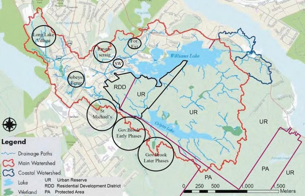
Sites of recent development and zoning of undeveloped land.
For more detail see the Williams Lake Water Flow Report, 2020.
Past
Multiple significant housing developments have been built in the Williams Lake Watershed in the past 20 years (positions circled on the map), many of which have altered natural water courses. The amount of development has had a severe effect on Williams Lake. A tipping point has been reached. Any further development would likely push the lake past its capacity to survive.
These developments represent a significant loss of permeable surface in the Watershed due to the addition of driveways, roads and parking lots. Instead of rainwater being retained and percolating slowly through the ground, water captured by storm drains moves rapidly through the Watershed. Sediments do not have time to settle and hydrocarbons do not readily evaporate in closed systems, making the water that is delivered into streams and lakes more highly contaminated – an added threat to water quality.
Present
The Church of Christ Development Corporation (C of C) lands (outlined in black on the map) are of particular concern. These lands hold the major stream connecting Colpitt Lake to Williams Lake – a vital supply of water to Williams Lake.
Currently, the eastern portion of the Church of Christ land has an Urban Reserve zoning which limits development for a number of years. However, the western portion is not similarly protected. This western part holds several smaller water courses (some seasonal) and wetlands. These feed into the Colpitt Lake-Williams Lake connector stream and into Governor’s Brook, an important source of water to Colpitt Lake. Undisrupted water flow from the Church of Christ lands is essential for the health of Governor’s Brook, Colpitt Lake and Williams Lake.
Future
An important rezoning application is before HRM. Councillor Shawn Cleary has submitted a motion to rezone the Church of Christ lands to Urban Reserve. This is just a first step in preventing major development in such a sensitive portion of the Williams Lake Watershed. In the long term, these lands need to be rezoned as open space protected area. This will ensure no future development is allowed to directly impact the health of this significant urban lake.
Our generation needs to protect this land for our future generations.